Hiking—or bushwalking, as Aussies call it—is probably not the first thing that comes to mind when you think of New South Wales (or Australia). Granted, there’s an embarrassingly large selection of fabulous beaches to steal your attention, but hiking opportunities shouldn’t be overlooked. They also give you a great excuse to venture beyond the coast (don’t worry, only for a while!) and explore more of the state—which I highly recommend!
With 800+ national parks and reserves, New South Wales is a paradise for nature lovers. The Blue Mountains are home to over 90 eucalyptus species, breathtaking escarpments, glens, and canyons. Kosciuszko National Park boasts Australia’s highest peak (Mt. Kosciuszko, 2,228m) and ski resorts, while Warrumbungle National Park features stunning volcanic landscapes and some of the clearest night skies in the world. Barrington Tops and Dorrigo are part of the ancient Gondwana Rainforests, and Mount Kaputar is the only place on Earth where neon-pink slugs exist.
Morton National Park is home to Fitzroy Falls and deep sandstone gorges, Bungonia National Park is a haven for caving, canyoning, and rock climbing, Booti Booti National Park is a unique 8 km peninsula with ocean on one side and a lake on the other, and Bouddi National Park is a stunning blend of coastal cliffs, secluded beaches, and lush rainforests near Sydney.
I won’t keep listing them—you get the idea, right? From alpine peaks to ancient rainforests and dramatic coastal vistas, NSW’s national parks offer endless hiking opportunities. In this post, I’m sharing my favorites with you.
Side note: Since this is a list of hikes I’ve personally done (or at least completed parts of, in the case of longer multi-day tracks), some iconic trails are missing. But as I continue exploring New South Wales, I’ll be adding more in the coming years!
My 14 favorite hikes in New South Wales
Bondi to Manly walk, Sydney
No, I’m not starting with the famous Bondi to Coogee Walk—not because it isn’t amazing, but because it’s more of a paved walk than a true hike. Instead, I recommend the 80 km Bondi to Manly Walk, a spectacular route that takes you all around Sydney Harbour, passing beaches, scenic headlands, parks, lookouts, and iconic neighborhoods. While some sections are paved, others offer true bushwalking—yes, even in the heart of Sydney Harbour, within Sydney Harbour National Park!
You don’t have to tackle the full 80 km at once. I’ve gradually completed most of it since moving to Sydney, but always in small sections—which is part of its charm. You can start and stop almost anywhere along the track, with plenty of restrooms, food stops, and water stations to keep you going.
Some of my favorite sections are:
Manly Beach to Manly North Head
Partially paved and partially on boardwalks and dirt tracks, this section offers some of Manly’s best viewpoints.
- Route: see it on the map here
- Length: 8.1 km (partial) circuit
- Highlights: Manly Beach, Shelly Beach, Hanging Swamp, The Barracks Precinct, Burragula Lookout and the Fairfax walk with distant views of the Sydney skyline, Collins Beach, Little Manly Beach
Dobroyd Head
Taking the steep walk up to Arabanoo Lookout and Crater Cove Lookout rewards you with stunning views of Sydney Harbour and Manly along the way, even a glimpse of the Sydney CBD from a high rocky outcrop.
- Route: see it on the map here
- Length: 2.4 km one way
- Highlights: Reef Beach, Dobroyd Lower lookout, Fairlight Lookout, Arabanoo Lookout, Crater Cove Lookout
Georges Head to Taronga Zoo Wharf
Georges Head Lookout is one of my favorite spots along the Bondi to Manly Walk, yet it remains surprisingly quiet. The same goes for the breathtakingly scenic loop around Bradleys Head Peninsula, where you’ll enjoy stunning views of Sydney and the Harbour Bridge for much of the walk.
This walk is great to combine with a visit to Taronga Zoo.
- Route: see it on the map here
- Length: 4.9 km one-way
- Highlights: Georges Head, Clifton Gardens, Bradleys Head peninsula, Athol Bay (requires a short detour)
Cremorne Point headland
Mostly paved (but not entirely stroller-friendly due to narrow sections and numerous stairs), this route winds through stunning bushland and gardens. The highlight, however, is Robertsons Point Lighthouse, offering a postcard-perfect view of Sydney.
On a hot summer day, cool off in the free MacCallum Seawater Pool, where you can swim with stunning views of Sydney.
- Route: see it on the map here
- Length: 3.2 km one-way
- Highlights: Robertsons Point Lighthouse (amazing views of Sydney CBD and the Harbour Bridge), MacCallum seawater pool (public pool)
Hermitage Foreshore Walk
This coastal walk from Bayview Hill Road (Rose Bay) to Nielsen Park passes adorable, calm beaches inside Sydney Harbour, including Queens Beach, Milk Beach, Hermit Beach, Tingira Beach, and Shark Beach. Enjoy Sydney skyline views, Shark Island, waterfront mansions, and the historic Strickland House, with picnic spots and benches along the way.
- Route: see it on the map here
- Length: 2 km one-way
- Highlights: Queens Beach, Milk Beach, Shark Beach and lots of scenic lookouts on the way!
Hornby Lighthouse & The Gap
It includes two of the most impressive clifftop viewpoints in Sydney: the one at Hornby Lighthouse and several different ones at the Gap. Excellent track for whale-watching.
- Route: see it on the map here
- Length: 4.1 km (partial) circuit
- Highlights: Green Point lookout, Camp Cove Beach, Lady Bay Beach, Hornby Lighthouse, The Gap lookouts
Best place to stay in Sydney:
- luxury: The Grace Hotel (4.5 stars, excellent location)
- mid-range: Cremorne Point Manor (scenic location, 10 minutes ferry ride from the CBD)
- budget: Nate’s Place Backpackers Sydney (hostel in Darlinghurst, a few blocks away from Kings Cross train station)
Royal Coast Track, Royal National Park
This 26 km trail from Bundeena to Otford is one of the world’s most stunning coastal hikes, with dramatic cliffs, sandstone formations, hidden rock pools (like the famous Figure 8), pristine beaches, waterfalls—including a spectacular twin cascade into the ocean—and migrating whales.
Typically hiked over two days with an overnight stay at Era Campground, it can easily be broken into shorter sections, as we did. Here are some great day hike options:
- Bundeena to Wedding Cake Rock: 5 km return
- Wattamolla to Curracurrong Falls & Eagle Rock: 8 km return
- Wattamolla to Big Marley Beach: 9 km return
I can’t pick a favorite—you can’t go wrong with any of them!
Best place to stay near Royal National Park:
- luxury: Stanwell Beach Glass House, Stanwell Park (luxurious holiday home with five bedrooms)
- mid-range: Tree Top Rest – Bright Water Retreat,Bundeena (one-bedroom apartment with a private pool)
- budget: Helensburgh Hotel, Helensburgh (various types of simple, clean, comfortable rooms)
- camping: Bonnie Vale campground (NSW Parks campground)
Grand Canyon track, Blue Mountains
This 6 km loop is the Blue Mountains’ most popular and accessible canyon walk, though not an easy one! It offers stunning views of towering sandstone walls, cascading waterfalls, lush creeks, and massive ferns—making you feel like you’re in Jurassic Park.
The trail descends steeply and includes a challenging hike back up, but it’s still an easy canyon trail overall, mostly shaded and pleasant even on hot days. You can park at the Grand Canyon car park along Evans Lookout Road, with other smaller car parks nearby.
Starting with a flat bushwalk, you’ll reach Evans Lookout for panoramic views before descending into the canyon, surrounded by giant ferns, tree roots, and trickling streams. After recent rain, narrow waterfalls tumble down the canyon walls.
For a detour (at this intersection!), explore a scenic slot canyon—narrow, stunning rock formations and ferns hang from the vertical walls. It’s an adventurous scramble, but worth it.
The return journey is more tiring, but equally rewarding with views of rock overhangs, waterfalls, and the canyon walls.
Grand Canyon track info:
- Trailhead & parking: Grand Canyon car park along Evans Lookout Road (in Blackheath)
- Length: 6 km loop
- See the Grand Canyon track on a map here.
Best place to stay in the Blue Mountains:
- luxury: Carrington Hotel, Katoomba
- mid-range: Metropole Guest House, Katoomba or Zig Zag Motel & Apartments, Lithgow
- budget: YHA Blue Mountains Katoomba, Katoomba
Tomaree Coastal Walk, Port Stephens, Nelson Bay
Spanning 27 km from Tomaree Head to Birubi Point, the Tomaree Coastal Walk is a breathtaking journey through some of New South Wales’ most spectacular coastal scenery. This multi-day track winds through pristine white sand beaches, rugged headlands, and lush bushland, offering a mix of challenging climbs and relaxed seaside strolls.
The Tomaree Head Lookout is a must-visit, with my all-time favorite coastal panorama, with sweeping views over Shoal Bay, Zenith Beach, and Fingal Spit. Other standout viewpoints include Big Rocky, Iris Moore, and Slot Canyon Lookouts, each showcasing the coastline’s dramatic cliffs and crystal-clear waters.
Don’t miss the chance to dip your toes in the stunning sands of Zenith and Fingal Beaches—perfect spots to relax before continuing your adventure. Box Beach and Wreck Beach feel even more remote.
My favorite sections are:
- Tomaree Head walk: 2 km return—see the trail map here
- Barry Park to Fingal Point: 2.9 km one-way; explore all the (unofficial) viewpoints on the headlands—see the trail map here
- Boat Harbour Whale Lookout to Slot Canyon Lookout: 2.4 km one-way—see the trail map here
Best place to stay in Nelson Bay:
- luxury: Anchorage Port Stephens, Port Stephens (beachfront location, heated swimming pool)
- mid-range: Hotel Nelson, Nelson Bay (with heated swimming pool)
- budget: Port Stephens Motel, Nelson Bay
Grand High Tops Circuit & Bluff Mountain, Warrumbungle National Park
The Breadknife and Grand High Tops Walk is the most iconic hike in Warrumbungle National Park and one of Australia’s best day hikes. It features stunning 360° views of an ancient volcanic landscape, with close-up views of striking rock formations like the 90-meter-tall Breadknife and the imposing Bluff Mountain.
With over 640 meters of elevation gain and 1,000+ steps, it’s a tough but rewarding hike. After reaching the Grand High Tops summit, continue towards Western High Tops and Ogma Gap Campground, passing Dows Camp.
From there, you can take a short but steep 2.5 km return detour to Bluff Mountain, which offers fabulous panoramic views. If you skip the detour, you’ll still get great views of Bluff Mountain on your way down the West Spirey Track, leading you back to Pincham Carpark.
Grand High Tops & Bluff Mountain track info:
- Trailhead: Pincham car park
- Length: ~17 km loop
- See Grand High Tops & Bluff Mountain track on a map here.
Best place to stay near Warrumbungle National Park:
- rooms: Acacia Motor Lodge in Coonabarabran
- camping: Camp Blackman and Camp Wambelong inside the park
Yulludunida track & peak, Mount Kaputar National Park
This short but intense hike leads to my favorite view over the volcanic landscape of Mount Kaputar National Park. The steep trail via woodland and a volcanic ridge leads to an impressive 360-degree panorama and a prime lookout over Yulludunida Crater at the end.
The real adventure begins where the official path ends as you need to scramble up the bluff’s side to the summit, using both your legs and hands. You’ll need a sense of adventure and a sturdy pair of hiking boots.
Yulludunida track info:
- Trailhead: Green Camp carpark
- Length: the formed track is 3 km return, reaching the summit adds about 500 m
- See Yulludunida track on a map here (though the final scramble is unmarked on trail maps).
Best place to stay in Kaputar National Park:
- rooms: Kaputar Motel in Narrabri
- camping: Bark Hut and Dawsons Spring campgrounds on the Kaputar Plateau
Solitary Islands Coastal Walk, Coffs Coast
Stretching 60 km from Red Rock to Sawtell, the Solitary Islands Coastal Walk is a spectacular journey through golden beaches, rocky headlands, and lush coastal rainforests along the stunning Coffs Coast.
Whether you tackle the full multi-day trek or just explore a section, it’ll be a memorable experience!
Some of my favorite sections are:
- Muttonbird Island Reserve: a short but rewarding path with panoramic ocean views and a chance to spot migrating whales.
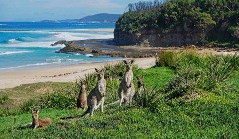
- Look At Me Now Headland: a scenic headland loop where kangaroos often graze against the backdrop of rolling waves. Continue to Emerald Beach via Dammerels Head if you have the time, it adds some more fantastic viewpoints.
- Diggers Beach to Charlesworth Bay Track: a coastal bushland connecting two amazing beaches.
- Macauleys Headland Walk: a peaceful cliff top track, offering views of Diggers Beach and a hidden cove.
Best place to stay in Coffs Harbour:
- luxury: Beachpark Apartments Coffs Harbour (4 stars, directly across Park Beach)
- mid-range: BIG4 Park Beach Holiday Park (villas and studios, beachfront location)
- budget: Ocean Park Motel & Holiday Apartments (directly across Park Beach)
Bungonia Slot Canyon (Red track), Bungonia National Park
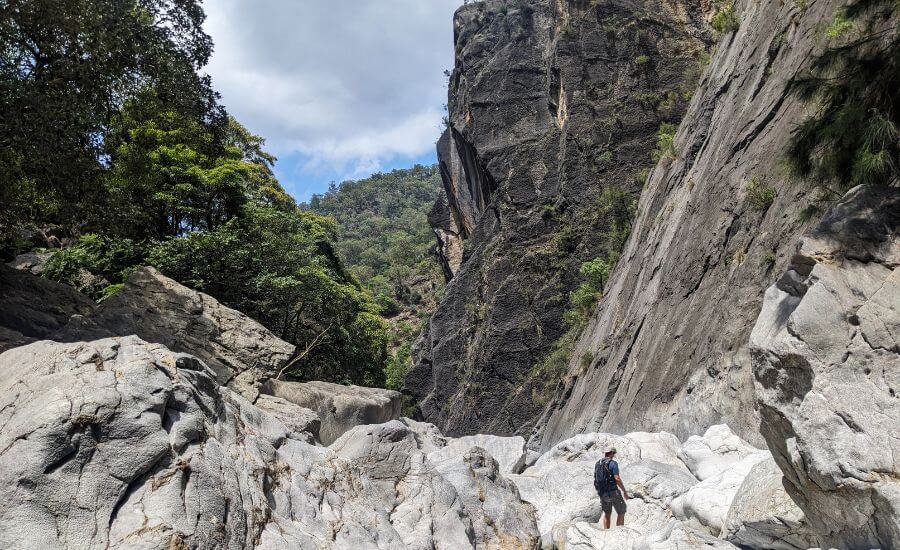
This hike is not for the faint-hearted! It’s a tough, technical adventure that plunges you down a steep trail into the jaw-dropping Bungonia Slot Canyon. Once inside, the real fun begins—you’ll navigate a maze of massive boulders, scrambling over and under them with no set path to follow (no gear needed, but you’ll definitely need your hands!).
The climb back up is just as steep, making this a true test of fitness, navigation skills, and a love for problem-solving. The best way to tackle it? Go clockwise—descending through the boulder field is much easier than climbing up it, and that’s the way we did it. I found it to be a thrilling and unforgettable challenge!
Red track info:
- Trailhead: David Reid carpark
- Length: 4.5 km loop (~5 hours return, because it’s a strenuous and technically challenging hike)
- Start your ascent by 2:30 pm on weekdays to avoid risks from nearby quarry work.
- Sign the visitor intention form at the visitor center before heading out—and don’t forget to sign out when you’re done!
- See Red track on a map here.
Best place to stay near Bungonia National Park:
- rooms: The Abbey Motel, Goulburn
- camping: Bungonia campground (inside the park)
Valley of the Dinosaurs and Ultimate Slot Circuit, Mugii Murum-ban State Conservation Area
Hidden deep in the wilderness, this hike takes you to a stunning valley, a picturesque grotto, and the coolest slot canyon we’ve found in NSW so far—but only if you can find the narrow, unmarked, and unofficial paths leading to them. The circuit track via the Valley of the Dinosaurs is absolutely worth the effort!
It’s not overly long or physically demanding, but offline maps and strong navigation skills are a must. That’s part of the fun!
Once you turn off Glen Davis Road, the unsealed road to the trailhead becomes very steep. If you’re in a 2WD, park at -33.1205809, 150.0473474, adding 1.5–2 km each way. Even in a 4WD, we walked part of the way—it’s that steep!
The trail climbs steeply but rewards you with stunning views. However, the best spots are all unmarked detours, so don’t rush past them:
- Pagoda Lookout: a natural rock pagoda surrounded by dramatic cliffs and dense rock formations, overlooking a narrow canyon and Dinosaur Valley. No set path—bush navigation required!
- Valley of the Dinosaurs: another unmarked gem, accessible by an impressive little glen.
- Mini Canyon Grotto
- Ultimate Slot Canyon
So they are the true highlights—miss them, and the trail becomes just another fire trail. Since this isn’t on any official maps, I made one to help you find all the must-see spots—it’s there, I promise!
Valley of the Dinosaurs track info:
- Trailhead: -33.12058, 150.04736 (off Glen David Road)
- Length: ~6.2 km loop
- See the track (along with the detours) on a map here. Please note that this is my draft with the coordinates we used, not a precise map, as I couldn’t find one.
Bingi Dreaming track, Eurobodalla National Park
If you’re after a walk with non-stop scenery, the Bingi Dreaming Track delivers. This 14 km coastal trail winds through the breathtaking landscapes of Eurobodalla National Park and the Sapphire Coast: heathlands, rugged cliffs, sandy beaches, coastal forests, and peaceful lakeshores—so there’s zero chance of getting bored along the way. Plus, it follows ancient Aboriginal Songlines, adding a deep cultural connection to the experience.
Wildlife? Plenty. Expect to see kangaroos, wallabies, and loads of birdlife, and if you visit between May and November, keep an eye on the ocean—you might just catch a humpback whale putting on a show!
If you’re short on time, the ~4.5 km section between Bingi Bingi Point to Mullimburra Point is especially delightful.
West Rim walking track, Morton National Park
Starting at Fitzroy Falls, where water plunges 80 meters into the lush Yarrunga Valley, the West Rim Track is a spectacular walk through Morton National Park. The well-maintained trail winds along the escarpment, leading to several breathtaking lookouts that offer sweeping views of the deep sandstone canyon, dense eucalyptus forests, and cascading waterfalls.
Along the way, you’ll pass Twin Falls, The Grotto, and Renown Lookout, each providing a unique perspective of the rugged landscape. There’s minimal elevation change, the path is wide and well-marked, and the lookouts are fenced, making it ideal for families with young children or beginner bushwalkers.
The waterfalls are best after heavy rains!
West Rim track info:
- Trailhead: Fitzroy Falls Visitors Centre
- Length: 2 km one-way
- See the track on a map here.
Best place to stay near Morton National Park:
- rooms: Twin Falls Bush Cottages, Fitzroy Falls
- camping: Carrington Falls campground in Budderoo National Park
Wonga Walk, Dorrigo National Park
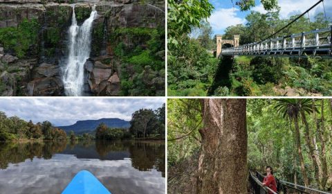
Wonga Walk takes rainforest beauty to the next level. Nestled in one of the world’s oldest Gondwana rainforests, it’s a lush escape filled with towering trees, hanging vines, vibrant wildlife, and birdsong—like stepping back in time.
This scenic loop features two stunning waterfalls. First up is Tristania Falls, a powerful cascade visible from a bridge. Don’t miss the short side trail just beyond—it offers a close-up view from the top, making for a great picnic spot (just watch out for leeches if it’s wet!).
Next is the iconic Crystal Shower Falls, where you can walk behind the waterfall! Follow the metal boardwalk through the gate, but be prepared for a refreshing mist if the water’s flowing strong. Then, cross the suspension bridge for a breathtaking view of the falls and the surrounding rainforest.
The loop can be walked in either direction, so just soak in the sights and enjoy the experience!
Wonga Walk track information:
- Trailhead: Dorrigo Rainforest Center or the Glade Picnic Area
- Length: 6 km loop
- See the Wonga Walk track on a map here.
Best place to stay near Dorrigo National Park:
- rooms: Frontier Motel, Dorrigo
- camping: Settlers Corner (private camping spot on the Bielsdown River, just a short walk from Dorrigo township)
Bouddi Coastal Walk, Bouddi National Park, Central Coast
One of the most popular walks on the Central Coast, the Bouddi Coastal Walk connects Putty Beach with MacMasters Beach, offering sweeping views, pristine beaches, and stunning rock formations along the way. During whale migration season, you’re likely to spot whales from the lookouts, and dolphins are frequent visitors to these waters as well.
Speaking of rock formations, this walk showcases some of the most striking natural patterns in Australia. The sandstone, with its intricate oval patterns and tessellated pavement (a rock surface fractured into polygonal blocks resembling a mosaic floor), gives the terrain an almost otherworldly appearance. The best spots to admire these formations are just before Bullimah Beach and on the southern side of Maitland Bay. The orange-hued rocks contrast beautifully against the turquoise waters, making them incredibly photogenic!
Bouddi Coastal Walk information:
- Trailhead: Putty Beach or MacMasters Beach
- Length: ~10 km one-way
- See track on a map here.
Coastal walking track of Wallarah National Park, Central Coast
This stunning coastal trail links Caves Beach to Pinny Beach in Wallarah National Park, taking you through clifftops, coastal bushland, secluded beaches, and dramatic headlands before reaching the wild, scenic shores of Pinny Beach.
Don’t rush past Caves Beach—it’s worth taking your time to explore the sea caves at low tide. If you’re not up for a long walk, the lookout above the caves offers incredible views with zero effort required!
But if you’re keen to keep going, the hike is well worth it. You’ll be rewarded with breathtaking coastal views, including views of (and access to) Spoon Bay and Pinny Beach.
Wallarah Coastal walking track information:
- Trailhead: Caves Beach
- Length: 2.8 km one-way
- See track on a map here.
Best place to stay on the Central Coast:
- luxury: Beachside Villa in Ettalong Beach (southern Central Coast), The Beachcomber Hotel & Resort in Toukley (northern Central Coast)
- mid-range: NRMA Ocean Beach Holiday Resort in Umina (southern Central Coast), Ibis Styles The Entrance (northern Central Coast)
- budget: Nightcap at Ocean Beach Hotel in Ettalong Beach (southern Central Coast), Blue Lagoon Beach Resort in The Entrance (northern Central Coast)
Best time for hiking in New South Wales
One of the best things about living in Sydney? You can be outdoors pretty much year-round. Even in winter, daytime temperatures rarely drop below 10°C, and in summer, they tend to sit comfortably between 20–30°C—rarely exceeding 30°C. (Well, except for those rogue heatwave days when stepping outside feels like walking into a giant hairdryer.)
But New South Wales is much more than just Sydney, and that means wildly different climates depending on where you go.
The further you venture from the coast, the more extreme the weather gets—hotter summers, colder winters, and temperatures that swing wildly throughout the day. So, is there a single best season for hiking? Not really. But the good news? No matter when you feel like lacing up your boots, there’s always a region with perfect hiking conditions.
Coastal walks?
Pretty much a safe bet year-round. The cooler months (April to November) usually bring the most pleasant weather for long hikes, but thanks to the coastal breeze, even summer hikes can be enjoyable—just don’t forget the sunscreen. And if you’re hiking near a beach, pack your swimsuit because that post-hike dip is going to be very tempting.
Oh, and if whale-watching is on your to-do list, aim for May to November for the best chance of spotting these ocean giants from the coastal tracks.
Heading inland?
Places like the Blue Mountains, Bungonia, Mount Kaputar, and Warrumbungle National Park are at their best between May and early October. If you’re planning to camp, though, winter (June–August) can get seriously chilly, so aim for May, September, or early October.
That said, summer isn’t a total write-off—many parks have lush glens and shady canyons where you can escape the heat. Some even have waterfalls or rock pools perfect for a refreshing dip. Because let’s be honest, nothing beats cooling off in a secret swimming hole after sweating your way through a bushwalk.
An alpine region in New South Wales?
Mount Kosciuszko National Park—which I really hope to visit this year—has true alpine conditions. If you’re keen on hiking and camping, summer is your best bet unless you enjoy hiking in snowshoes.
What to pack for NSW hikes? (What actually helps)
You don’t need fancy gear for most NSW walks, but a few well‑chosen basics make a big difference — especially once tracks get wet, weather changes quickly, or the walk ends up being longer than planned.
Comfortable walking shoes
Good grip matters more than brand names here. Wet tracks, slippery rock crossings and muddy rainforest paths are common. The Columbia Newton Ridge waterproof hiking boots (both women’s and men’s versions) are supportive, grippy, and comfortable straight out of the box, which is always a win.
Rain protection (two useful options)
- For sudden downpours or short walks, a lightweight rain poncho (like the Frogg Toggs Ultra‑Lite style) is brilliant — packs tiny, goes on fast, and keeps both you and your backpack dry.
- For windy coastal walks or longer hikes, a proper rain jacket is more comfortable. Lightweight options like the Columbia Arcadia (women) or Glennaker (men) jackets work well without feeling bulky.
Sun protection
Yes, even in the forest. A wide-brim hat and sunscreen are still essential, especially on exposed lookouts, gorge rims and coastal sections.
Reusable water bottles
Bring more water than you think you’ll need, especially in summer. A stainless steel (metal) bottle is a solid choice — no microplastics, keeps water cooler for longer, and survives being knocked around in a backpack. We like insulated metal bottles for longer days.
Snacks
For short walks, simple snacks, like energy bars, are fine. For longer hikes, we’ve learned to add one or two more filling options — not cheap and not something we bring every time, but genuinely helpful when energy dips and legs start to complain.
Small first‑aid kit
Nothing fancy — just enough for blisters, scrapes and the usual trail mishaps. It’s one of those things you hope not to use, but you’re very glad to have when needed. You can buy a pre-made kit or make one for yourself.
Swimmers and a quick‑dry towel
Rock pools and waterfalls have a way of changing plans. A compact, quick‑dry towel takes up very little space and earns its place surprisingly often.
Insect repellent
Especially after rain, and especially in rainforest sections. Mozzies are simply part of the ecosystem, along with leeches. Repellent makes them much more tolerable. If you don’t like spray, use patches. Bands are practical for multi-day hikes and longer camping trips.
Offline maps or downloaded trails
Phone reception is unreliable once you leave towns. Download maps or trails in advance so you’re not standing at a trailhead staring at a loading screen.
Travelling with kids?
A child carrier is far more practical than a pram on rainforest tracks, and throwing in a spare layer is rarely a mistake — someone will get wet, cold, or both.
Travelling with kids? Add a baby carrier for uneven tracks and a spare layer — someone will get wet or cold, it’s almost guaranteed.


Leave a Reply