Living in Sydney, the best kind of holiday is a road trip along the stunning NSW coastline. North or south? That’s a debate you’ll never win. Either way, pick an oceanfront campsite or cabin, and make sure you don’t miss the real scenic rewards.
Because the coast isn’t just about fabulous beaches — it also offers some of the most breathtaking coastal walks in the country. Over the years, I’ve made it a mission to track down the best of them. So in this post, I’ve collected my favourite short and scenic coastal walks in NSW, heading from the stunning south to the blissful north (or the blissful south and the stunning north? Whatever).
25 short & scenic coastal walks in New South Wales – from south to north

Green Cape Lighthouse Walk, Beowa National Park
You can’t go much southern than Beowa National Park and its impressive Green Cape Lighthouse walk. This short and easy walk is absolutely drenched in atmosphere: the lighthouse is dramatically perched on the edge of a rugged headland, with the Pacific Ocean stretching endlessly in front of you. Since 1883, the lighthouse has watched over a coastline of crashing waves and windswept heath. Throw in the shipwreck legends, and suddenly you’re standing in the middle of a storybook adventure.
During migration season (May–November), this headland doubles as one of the best whale-watching spots in NSW. To be fair, you could say that about most of these walks, so let’s just get it out of the way now. Still, when a humpback swims so close to shore it looks like it’s showing off — and then throws in a full breach — it’s hard not to feel like you’ve scored front-row seats.
If you’re keen for a longer walk, take the 7 km Bittangabee Bay to Green Cape walking track.
Green Cape Lighthouse Walk practical information:
- Trailhead: Green Cape Lighthouse car park, Beowa National Park (near Eden)
- Length: A few hundred meters
- Difficulty: Very easy
- Highlights: Historic lighthouse, shipwreck history, whale watching, dramatic headland views
- Best accommodation: Beowa National Park campgrounds or the Wonboyn Cabins
Wagonga Head & Australia Rock, Narooma
Narooma is an absolute gem of the Sapphire Coast, and the walk around Wagonga Head is less of a hike and more of a leisurely wander. Park at the end of Bar Rock Road and stroll to the Bar Rock Lookout for sweeping views.

From there, take the stairs down towards the breakwall, but keep your eyes open for the star attraction: Australia Rock. This rock has an exactly Australia-shaped hole, and you can even climb on it at low tide. A photo is, of course, mandatory.


Don’t stop at the rock, though. Keep strolling along the breakwall and you’ll likely meet the local seal colony. They like sunbathing on the rocks, diving through the waves, and generally put on a show. They were the most laid-back, entertaining seals I’ve ever come across on the Australian coast.
Wagonga Head practical information:
- Trailhead: Car park at the end of Bar Rock Road
- Length: A few hundred meters
- Difficulty: Easy
- Highlights: Australia Rock, seal colony, Wagonga Inlet views
- Best accommodation: The Harrington Serviced Apartments in Narooma
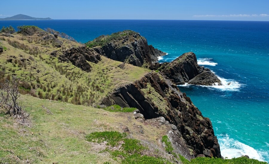
Wasp Head walk, Murramarang National Park

The 2 km return walk to Wasp Head includes secluded bays, dramatic rock platforms, and lush forest. Marvel at the natural patterns in the rocks, the stingrays and seals whom you can see in the crystal clear water below (if you’re lucky), and choose your perfect picnic spot.
Wasp Head practical information:
- Trailhead: Wasp Head car park (at the end of Wasp Head Road, South Durras)
- Length: 2 km return
- Difficulty: Easy–Moderate
- Highlights: coastal forest, rock platforms and natural patterns, marine life
- Best accommodation: NRMA Murramarang Beachfront Holiday Resort
Kiama Blowhole, Kiama
The name Kiama comes from the Aboriginal word kiarama, meaning “place where the sea makes a noise.” And that couldn’t be more accurate since the Kiama Blowhole is one of those rare natural spectacles that never gets old, no matter how many times you’ve seen it.

At first glance, it looks like a coastal geyser, erupting every few minutes. In reality, it’s a natural opening in the rock face where the ocean surges through and shoots skyward. The size of the spray depends on the swell — sometimes it’s just a gentle puff, other times it’s a full-on explosion of water reaching 10 metres high. On the right day, locals swear it can rocket up to 30 metres.
There are multiple viewing platforms around the blowhole, so you can watch the show from different angles. The surrounding walking paths also connect you to the rest of Kiama’s coastal highlights, making it easy to turn a quick stop into a leisurely wander.
Blowhole practical information:
- Trailhead: car parks along Blowhole Point Road, Kiama
- Length: A few hundred meters (linked to the 22 km long Kiama Coastal Walk)
- Difficulty: Very easy
- Highlights: Natural blowhole eruptions, ocean views
- Best accommodation: Kiama Harbour Cabins in Kiama
Bombo Headland & The Boneyard, Kiama Downs

The Bombo Headland walk takes you to the remnants of an old basalt quarry, the Boneyard: a mind-blowing landscape of hexagonal rock columns jutting out into the sea. It’s a dramatic, almost surreal landscape — Australia’s version of the Giant’s Causeway.
The Boneyard is a dream for photographers: impressive waves crash against the dark stone pillars, sending spray high into the air, while the jagged cliffs create endless angles and textures to capture. Sunrise and sunset are particularly magical, when the light softens and the rocks glow with colour.

The Boneyard and Bombo Headland is part of the 22 km long Kiama Coast Walk, but you can easily access them directly from two (free) parking lots, connected by a path along the railway:

One is closer to the quarry, but we recommend parking in the other one, located closer to Boneyard Beach. From there you can do a hike all around Bombo Headland (~3.8 km), and it’s truly worth it, with fabulous coastal views and access to the sheltered, crystal clear bay at Boneyard Beach, perfect for snorkeling.
Bombo Headland & The Bonoyard practical information:
- Trailhead: At the end of Cliff Drive in Kiama Downs, off the Princes Highway
- Length: 3.8 km (orange route on the above map) + walk in the quarry (red route)
- Difficulty: Medium (rough terrain and no defined path in the quarry)
- Highlights: Basalt columns, dramatic waves, snorkeling at the Boneyard Beach
- Best accommodation: Kiama Harbour Cabins in Kiama
Cathedral Rocks, Kiama Downs

Just down the road from Bombo, Kiama continues to show off with its geological wonders. Cathedral Rocks are a collection of volcanic formations that have been battered by the sea into spectacular shapes. Something like a cathedral, yes. Walk around on the rock platform, climb on the rocks for elevated view, and marvel at the crystal clear tidal pools. Find the small cave, a photographer’s favorite: if you go inside, you’ll see the Cathedral Rocks framed by the cave entrance.
Accessing this rock platform isn’t a long walk, but a short scramble over the rocks from the south end of Jones Beach. The key here is timing: it’s only accessible at low tide. The waves make the rock platform quite unsafe at high tide.
Cathedral Rocks practical information:
- Trailhead: South end of Jones Beach, Kiama Downs
- Length: ~1 km return
- Difficulty: Easy–Moderate (rock scrambling, tide dependent)
- Highlights: Volcanic rock formations, sea cave
- Best accommodation: Kiama Harbour Cabins in Kiama
Bare Island, Kamay Botany Bay National Park, Sydney
Bare Island is one of those places that feels like a movie set — and in fact, it was (Mission Impossible II, if you remember Tom Cruise dangling off the fort). The short walk across the wooden footbridge takes you to the island, where you can enjoy panoramic views over Botany Bay. In order to actually access and explore the historic 19th-century fort you need to book a guided tour.

The island is quite small, so it’s more of a wander than a hike, but the setting is spectacular. You can continue strolling on the oceanfront walkway, marveling at the fort and Botany Bay from other viewpoints and rock platforms.
The surrounding waters are a marine reserve, making it one of Sydney’s best snorkelling and diving spots. If you’re keen for a longer walk, a 5.8 km loop takes you around Henry Head and Cape Banks.
Bare Island practical information:
- Trailhead: Bare Island car park, La Perouse
- Length: A few hundred meters
- Difficulty: Very easy
- Highlights: Historic fort, Botany Bay views, snorkelling/diving
- Best accommodation: Southend Hotel, Maroubra, Sydney
Hornby Lighthouse, Sydney Harbour National Park, Sydney
If you want a walk that feels iconic and easy, Hornby Lighthouse is a winner. Starting from Camp Cove or Watsons Bay, the short trail takes you along South Head with sweeping views across Sydney Harbour, the city skyline, and out to the Pacific. The highlight is the candy-striped Hornby Lighthouse itself, perched dramatically on the cliffs since 1858.


It’s one of those spots where you can stand and take in the full contrast of Sydney — wild ocean on one side, glittering harbour on the other. The walk is short and family-friendly, and if you’re lucky, you might even spot whales cruising past during migration season.
Have your swimsuits with you for a refreshing swim at the naturally sheltered Camp Cove Beach in summer. And don’t miss the Gap lookout on your way back to Watsons Bay.
Hornby Lighthouse practical information:
- Trailhead: Camp Cove car park, Watsons Bay (or Watsons Bay Wharf if you come from the CBD)
- Length: ~1.5 km return
- Difficulty: Easy
- Highlights: Hornby Lighthouse, Camp Cove Beach, Sydney Harbour views, ocean cliffs
- Best accommodation: Watsons Bay Boutique Hotel, Watsons Bay, Sydney
Dobroyd Head, Balgowlah Heights, Sydney
If you want jaw-dropping harbour views without breaking a sweat, the short walk from Tania Park to the Dobroyd Head lookouts is perfect. Dobroyd Lookout and Arabanoo Lookout are both literally just a few steps away from the Tania Park parking spots, offering views of Sydney Harbour and its entrance, South Head, North Head, Manly and even the Sydney CBD in the distance.

If you’re willing to put some effort into the views, continue to the Dobroyd Lower Lookout. This 700 meters walk goes steeply downhill, so you’ll need to climb back on the steps in the end. But the views are breathtaking all the way.
The Dobroyd Head lookouts are part of the longer Spit to Manly walk, but this little section is a great standalone stroll, too, and these lookouts are some of the best vantage points in Sydney. It’s the kind of spot that makes me stop and remember why I live in Sydney.
Dobroyd Head practical information:
- Trailhead: Tania Park car park, Balgowlah Heights
- Length: ~1.5 km return
- Difficulty: Easy–Moderate (very easy without the Dobroyd Lower Lookout)
- Highlights: Harbour entrance views, bushland
- Best accommodation: Q Station heritage rooms in Manly, Sydney
Fairfax Walk, Manly North Head, Sydney Harbour National Park, Sydney

The Fairfax Walk is one of Sydney’s most accessible and rewarding short walks. Starting from the North Head Visitor Centre, the paved loop takes you through coastal heathland to a series of lookouts perched high above the ocean. The views are immense — you’re standing at the entrance to Sydney Harbour, with cliffs dropping away beneath you and the city skyline in the distance.
It’s an easy, family-friendly walk with plenty of benches and viewing platforms. You can continue the track all around Manly North Head, making it a ~10 km loop.
Fairfax Walk practical information:
- Trailhead: North Head Visitor Centre, Manly
- Length: 1 km loop
- Difficulty: Very Easy (paved path)
- Highlights: Ocean cliffs, Sydney Harbour entrance, city skyline views
- Best accommodation: Q Station heritage rooms in Manly, Sydney
Mount Ettalong Lookout, Central Coast

The Mount Ettalong Lookout is not the roadside one, it’s better than that. But you need to watch out for the small car park along Patonga Drive, because it’s easy to miss. Once there, take the wide forest path that leads you to astonishing views over Pearl Beach, Broken Bay and Lion Island.
The first viewpoint is a natural one from the clifftops, and you need to be careful not to venture too far to the edge. The second viewpoint is a proper, fenced lookout though, and the view is very similar! It’s one of the best panoramic views on the Central Coast.
Mount Ettalong Lookout practical information:
- Trailhead: car park just off Patonga Drive
- Length: 1.5 km return
- Difficulty: Easy
- Trailmap here.
- Highlights: Panoramic views over Pearl Beach, Broken Bay, Lion Island
- Best accommodation: NRMA Ocean Beach Holiday Resort in Umina
Box Head Lookout, Bouddi National Park, Central Coast
If you want to feel like you’ve truly left the city behind, this is the walk. It’s a roughly 3.5 km return track that starts with an amazing view right from the parking lot, looking over the wild Tallow Beach.
Then it takes you through beautiful angophora forest to the very tip of Box Head. The trail opens up to an unfenced clifftop with absolutely jaw-dropping views south over the Hawkesbury River mouth, Broken Bay, and back towards Palm Beach.

It’s an easy hike, but not a casual stroll. Proper shoes are recommended, because the terrain is uneven, with roots and rocks. A high clearance car is also recommended to reach the trailhead, because the last bit of Hawke Head Drive is an unpaved road, with some larger rocks and potholes.
Box Head practical information:
- Trailhead: Box Head track car park, Hawke Head Drive, Killcare Heights
- Length: ~3.4 km return
- Difficulty: Moderate
- Trailmap here.
- Highlights: Broken Bay views
- Best accommodation: Killcare Beach House in Killcare
Bullimah Spur Track, Bouddi National Park, Central Coast

The Bullimah Spur Track is a great, shorter alternative to the Bouddi Coastal Walk in Bouddi National Park. It leads you through scenic bushland and offers several rocky outcrops with stunning views on the way. The highlight is Bullimah Outlook, the rock platform at the end, with views over Broken Bay and Putty Beach. It’s the perfect spot to sit for a while and just soak it all in. But keep an eye out for side trails before the final lookout. They’re just as stunning, offering views over Maitland Bay.
I recommend wearing proper shoes, because the terrain has uphills and downhills, occasionally roots and rocks.
Bullimah Spur Track practical information:
- Trailhead: Maitland Bay Information Centre car park, Bouddi NP
- Length: 2.6 km return
- Difficulty: Moderate
- Highlights: Rocky outcrops, Maitland Bay views, Putty Beach views
- Best accommodation: Killcare Beach House in Killcare
Anna Bay sand dunes / Birubi Beach, Port Stephens
This isn’t your typical coastal walk. Forget firm trails; this is about the epic, shifting landscape of the largest moving coastal sand dunes in the Southern Hemisphere. Standing on top of the Anna Bay sand dunes, it’s hard to believe you’re still in New South Wales. Stretching for around 32 kilometres along Birubi Beach, some of these dunes rise higher than a four-storey building.

Exploring them on your own is easy. Park at Birubi Beach, head down the stairs, and wander inland towards the dunes. Within 20–30 minutes you’ll reach the biggest ones. There’s no marked track, but you’re never really lost — the beach, forest, and town are always in sight. I love the northern end best: it’s usually quiet, and you might only spot a handful of people scattered across the sand.
The southern end, on the other hand, is where the action is. This is where you’ll find the adventure tours — quad biking, sandboarding, and even camel rides at sunset if you’re after something truly memorable.
Anna Bay practical information:
- Also known as Stockton Sand Dunes, Port Stephens Sand Dunes or Worimi Sand Dunes
- Trailhead & parking: one of the free car parks at Birubi Point Surf Life Saving Club, or further back along James Paterson Street (overflow parking spots)
- Length: Choose your own adventure (1–5 km depending on energy)
- Difficulty: Easy–Moderate (walking on sand is a workout)
- Highlights: Towering sand dunes, desert-meets-ocean scenery, adventure activities
- Best accommodation: Melaleuca at One Mile in Boat Harbour (boutique hostel and campground)
Tomaree Head, Tomaree National Park, Port Stephens
The Tomaree Head summit walk is one of Nelson Bay’s star attractions — and for good reason. The view from the top isn’t just one of the best in Australia; it’s one of the best coastal panoramas you’ll find anywhere, full stop.

Be warned though: this 2.2 km return walk may be short, but it’s basically uphill the whole way. Your legs (and glutes) will definitely feel it, but every step is worth it once you reach the summit.
At the top, two viewing platforms give you different perspectives. Facing south, you’ll get a breathtaking bird’s-eye view over four turquoise bays, the rolling green hills between them, the wide sweep of Port Stephens, and out to Fingal Island and the famous Fingal Spit. Turn north, and the outlook shifts to Yacaaba Head and Boondelbah Island, with the Pacific stretching endlessly beyond.
Tomaree Head practical information:
- Trailhead: Mount Tomaree lower parking area, near Zenith Beach
- Length: 2.2 km return
- Difficulty: Moderate (steep climb)
- Highlights: 360° views of Port Stephens, islands, Zenith Beach
- Best accommodation: Hotel Nelson in Nelson Bay (with heated swimming pool)
Dark Point / Little Gibber, Myall Lakes National Park
If it’s solitude you’re after, Dark Point (also known as Little Gibber) is the place to find it. This headland is a culturally significant site for the Worimi people and serves as the gateway to the magnificent Mungo Beach — the third-longest beach in New South Wales, stretching 18 km north to Big Gibber Headland. Out here, there are no crowds, no traffic, no noise — just soft white sand, clear blue water, and the soundtrack of wind and waves. It feels like stumbling onto your own private paradise.

The dunes at Dark Point aren’t as towering as the ones at Anna Bay, but they have a raw, untamed beauty that’s just as striking. From the top, you get sweeping views over Mungo Beach, and if you keep walking, you’ll eventually reach its southern end. Again, there’s no defined track in the sand, but the beach gives you direction.
From the southern end of Mungo Beach, a narrow sandy track winds up to the headland — the true Dark Point. The climb is gentle, and once you’re at the top, you’re rewarded with panoramic views across both Mungo Beach and Jimmys Beach.
Dark Point practical information:
- Trailhead: Dark Point walking track car park, off Mungo Brush Road
- Length: 2 km return
- Difficulty: Easy–Moderate (soft sand)
- Highlights: Sand dunes, cultural significance, Mungo Beach
- Best accommodation: Mungo Brush campground in Myall Lakes National Park, or Tea Gardens Hotel in Tea Gardens
Sugarloaf Point Lighthouse, Seal Rocks

There’s something magical about a lighthouse, and the one at Sugarloaf Point is a classic. The walk up to the lighthouse itself is short and steep, but the reward is a spectacular view over the rugged coastline and the cluster of rocks that give the area its name. But the best views are not from the lighthouse: they’re from a grassy terrace halfway up the hill. (Yes, it’s usually worth wandering off to the side tracks.)
Needless to mention, it’s also a fantastic spot for whale watching during migration season (May–Nov).
Sugarloaf Point Lighthouse practical information:
- Trailhead: Lighthouse Road car park, Seal Rocks
- Length: 1 km return
- Difficulty: Easy–Moderate (short, but steep)
- Highlights: Historic lighthouse, rugged coastline
- Best accommodation: Reflections Seal Rocks Holiday Park
Korogoro walking track, Hat Head National Park

Hat Head National Park is criminally underrated. The Korogoro walking track is a brilliant 3 km loop, one of the most scenic coastal trails in all of Australia! It showcases the park’s raw beauty: coastal rainforest, windswept headlands, and even some hidden sea caves carved by the relentless ocean. It’s diverse, dramatic, and you’ll likely have it mostly to yourself. And oh, those fabulous turquoise bays.
Korogoro walking track practical information:
- Trailhead: Hat Head Gap car park
- Length: 3.2 km loop
- Difficulty: Moderate
- Highlights: Coastal rainforest, sea caves, headland views
- Best accommodation: Hat Head Holiday Park in Hat Head
Connors walking track to O’connors Beach, Hat Head National Park
If Korogoro gives you a taste for Hat Head, the Connors walking track is the next step. It’s a bit longer at 4 km one-way, but completing it only until the first beach, O’connors Beach already gives you plenty of pretty headland views and wild beach vibes.

For a longer walk, follow the track towards Third Beach and the Kemp’s Corner. The views are captivating all along this wild stretch of coast.
Connors walking track practical information:
- Trailhead: Hat Head Gap car park
- Length: 1.2 km return
- Difficulty: Moderate
- Trailmap here.
- Highlights: Remote beach, rugged coastline
- Best accommodation: Hat Head Holiday Park in Hat Head
Smoky Cape Lighthouse, Hat Head National Park

Another lighthouse, another breathtaking view. Perched high on a dramatic headland, the Smoky Cape Lighthouse is one of the oldest and tallest in Australia. The short walk up to the lighthouse precinct is steep but paved and incredibly scenic. From the top, the views south over Smoky Beach are stunning. It’s a powerful, windswept spot that feels like the edge of the world.
The Smoky Cape picnic area down at the car park is an ideal spot for snacks or BBQs. If you visit in the morning or late in the day, you have a good chance of bumping into local kangaroos.
Smoky Cape Lighthouse practical information:
- Trailhead: Smoky Cape car park, Hat Head NP
- Length: 1 km return
- Difficulty: Easy–Moderate (steep paved path)
- Highlights: Coastal views
- Best accommodation: Smoky Cape campground, or Hat Head Holiday Park in Hat Head
Monument Hill walking track, Arakoon National Park

Right next to Hat Head National Park (or rather north of it), this walk is a fascinating blend of natural beauty and history. The short 1.5 km trail takes you up Monument Hill, offering fantastic views over Trial Bay and the historic Trial Bay Gaol below. Then you continue further towards Little Beach, a picturesque cove with a picnic area popular among local kangaroos, too.
You can start the track either at the Trial Bay or the Little Beach car park. Visiting the prison and its exhibits is absolutely worth it. It’s quite well-preserved, and you’ll realize it wasn’t just a prison either, but an internment camp for Germans and German Australians.
Monument Hill practical information:
- Trailhead: Trial Bay Gaol car park, Arakoon National Park
- Length: 3 km return
- Difficulty: Easy
- Highlights: Trial Bay Gaol ruins, coastal views, Little Bay
- Best accommodation: Heritage Guesthouse in South West Rocks
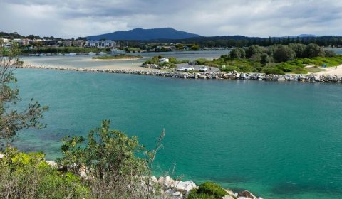
Urunga Boardwalk, Coffs Coast
I’ve seen many boardwalks through tidal wetlands and mangrove forests in New South Wales, but the Urunga Boardwalk is my absolute favorite! It’s a fascinating wetland walk where two rivers—the Kalang and the Bellinger—meet the ocean.


tide times do make a difference!
Tide times matter here because they completely transform the landscape. At high tide, it’s a series of beautiful, shallow lagoons. At low tide, it becomes a muddy playground for crabs and birds. It’s especially exciting to do the short walk (2 km return) at both low and high tide to see the difference.
Urunga Boardwalk practical information:
- Trailhead: Urunga Lagoon car park, just off Morgo Street
- Length: 2 km return
- Difficulty: Easy
- Highlights: Tidal wetlands, river mouth views, birdlife
- Best accommodation: Riverside Holiday Resort Urunga in Urunga
Muttonbird Island Nature Reserve, Coffs Harbour
This is a truly unique walk and the best thing to do in Coffs Harbour for nature lovers! A man-made breakwall connects the Coffs Harbour marina to (car free) Muttonbird Island, a sacred site for the Gumbaynggirr people. The walk to the top is a short, steep climb, but you’re rewarded with great views of the harbour, the coast and the hinterland.

The island is home to the Wedge-tailed Shearwater (the muttonbirds) that nests here from August to April. Visit at sunset during nesting season to witness thousands of birds returning to their burrows – the sound is unforgettable.
Muttonbird Island practical information:
- Trailhead: Coffs Harbour Marina car park
- Length: 1.5 km return
- Difficulty: Moderate (short, steep climb)
- Highlights: Shearwater colony, harbour views, cultural significance
- Best accommodation: Ocean Park Motel & Holiday Apartments in Coffs Harbour
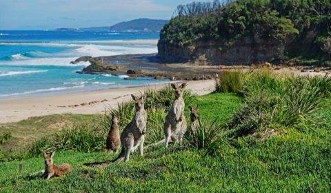
Look At Me Now Headland, Coffs Coast
As the name suggests, you’ll be saying “look at me now!” to the mobs of eastern grey kangaroos that call this headland home. They won’t look but will happily munch on grass while you take photos from a respectful distance.

This is an easy, gentle walk around a grassy headland with lovely coastal views. And it’s a guaranteed winner for wildlife spotting, unless you go in the middle of a hot day when all the kangaroos are taking a nap under the shady bush. In addition to the kangaroos, the headland offers breathtaking views of Moonee Beach and Shelley Beach, as well as access to the sheltered, sandy cove of Shelley Beach.
Look At Me Now practical information:
- Trailhead: Look At Me Now car park, Emerald Beach
- Length: ~2 km loop
- Difficulty: Easy
- Highlights: Kangaroos, grassy headland, ocean views
- Best accommodation: Ocean Park Motel & Holiday Apartments in Coffs Harbour, or Discovery Parks Holiday Park in Emerald Beach
Cape Byron Lighthouse Walk, Byron Bay
The famous one. Yes, it can be busy, and yes, you’ll be sharing the path with activewear-clad influencers, but the Cape Byron walk is an absolute must-do. The 3.7 km loop takes you through rainforest and along windswept cliffs to the most easterly point of the Australian mainland.

My tip? Get up ridiculously early and do the walk for sunrise. Watching the first rays of sun hit the continent from the lighthouse is a memory you won’t forget.
Cape Byron practical information:
- Trailhead: Captain Cook Lookout car park, just off Lighthouse Road, Byron Bay
- Length: 3.7 km loop
- Difficulty: Moderate
- Highlights: Most easterly point of mainland Australia, dramatic cliffs, lighthouse
- Best accommodation: YHA Byron Bay (private rooms and dorms) in Byron Bay
Best time to go
The beauty of NSW’s coast is that you can walk it year-round — but each season has its perks.

- Summer (Dec–Feb): Long days, warm water, and the perfect excuse to combine a walk with a swim. Just be prepared for the heat. Start early, pack plenty of water, and don’t forget the sunscreen.
- Autumn (Mar–May): My personal favourite. The weather is still warm, the ocean is swimmable, and the crowds thin out once school holidays are over. It’s the sweet spot for road trips. Except once the May storms arrive. The Easter weekend is our usual camping season cut off date.
- Winter (Jun–Aug): Cooler walking weather, fewer people, and whale-watching! Rent a beach house or cabin, bring a thermos of coffee, and enjoy having the trails almost to yourself.
- Spring (Sep–Nov): Wildflowers, migrating whales, and that first hint of summer energy. It’s a brilliant time to explore the blooming headlands.
If you’re chasing whales, aim for May to November. If you’re chasing swims, stick to late spring through early autumn.
Where to stay along the way
One of the joys of a coastal road trip is waking up to the sound of waves. Luckily, NSW has no shortage of oceanfront campsites and cabins. Here are a few favorites along the route:
South Coast
- Narooma: Stay in one of the lovely rooms or apartments at The Harrington Serviced Apartments.
- Murramarang National Park: Both Pebbly Beach Campground and Pretty Beach Campground are famous for kangaroos on the sand.
- Kiama: the Kiama Harbour Cabins offer rooms and cabins at the very best location, walking distance from the historical lighthouse and the famous Blowhole.

Sydney
- South Sydney: 3-star Southend Hotel is in Maroubra, less than 10 minutes’ walk from Maroubra Beach.
- Manly: Q Station on Manly North Head has a private beach and beautifully restored historical spaces.
- CBD: The Grace Hotel (4.5 stars) is at an excellent location, right in the heart of the CBD.
- budget option: Nate’s Place Backpackers Sydney in Darlinghurst, a few blocks away from Kings Cross train station.

Central Coast
- Bouddi National Park: Putty Beach Campground is a classic — right on the sand, with easy access to the coastal tracks.
- Killcare: visit the trail of Bouddi National Park from the comfort of Killcare Beach House, a spacious holiday home with a private beach area.
- Umina/Pearl Beach: Cute beach cottages and cabins, like the ones at NRMA Ocean Beach Holiday Resort
Mid North Coast

- Port Stephens: Hotel Nelson is a great base to explore the area.
- Hat Head National Park: Smoky Cape Campground is a gem, tucked between rainforest and beach. Hat Head Holiday Park is ideal for a more luxurious nature getaway (I mean, you’ll have hot shower, and maybe a beachfront cabin).
- Coffs Harbour: the Ocean Park Motel & Holiday Apartments is directly across Park Beach.
Byron Bay
- If you want to splurge, stay at Byron Palms Guesthouse & Spa; if not, there’s the Reflections Byron Bay Holiday Park, right by the beach.
What to pack

After countless bushwalks and coastal rambles, here’s what I usually have for sensible comfort and peace of mind for those adventures that can easily end in a coffee shop (strictly before 3pm, otherwise you’d find them closed).
Footwear
- Proper hiking shoes with good grip, like the Columbia Newton Ridge Plus, both for women and men – Essential for rocky patches, slippery steps, and those unexpected mud puddles that mysteriously appear even after a dry spell. Don’t twist your ankle in flip-flops, most of these walks are not strolls on a paved promenade.
- Water shoes or reef shoes – If your hike ends at a beach or rock pool, these are a godsend to explore the rock at low tide.
Sun & insect protection
- Wide‑brimmed, adjustable sun hat (and this is my favorite for kids) – The Aussie sun is fierce even in winter. A hat with a chin strap means it won’t fly off when the coastal breezes decide to make an appearance.
- Reef‑safe sunscreen (high SPF) – Protects your skin and the beautiful marine life if you end up swimming. A good habit for every outdoor day.
- Insect repellent bands – For those lush, shaded bush sections or twilight walks.
Hydration & the fuel for fun
- Durable reusable water bottles (preferably metal to avoid microplastic) – Always carry more water than you think you’ll need.
- Electrolyte‑boosted drinks and energy bars – For those moments when the kids (or you) declare “I can’t possibly take another step!” . Most of the time these are simple snacks, like energy bars, but for longer hikes, we’ve learned to add one or two more filling options, like eggs, beef jerky, almonds and nuts (the point is: lots of protein!).
- Compact picnic blanket – For impromptu breaks, lunch with a view, or simply sitting on damp ground without getting a soggy bottom.
Safety & navigation (just in case)
- Compact first‑aid kit – Small scrapes, unexpected blisters, or a sudden spider bite (rare, but good to be prepared). Ours always has band‑aids, antiseptic wipes, and anti‑itch cream.
- Compact headlamp or small torch – For unexpected detours, chasing sunset views, or those bathroom visits at dusk.
- Printed map or reliable offline map app on your phone – Phone reception can be patchy in national parks. Don’t trust Google Maps blindly.
For the little explorers
- Child‑friendly binoculars – Turn any view into a treasure hunt for birds or distant boats.
- Small backpack for kids (with snacks inside) – They love carrying their own gear (if they don’t, they need to get used to it, anyway), and it gives them a sense of purpose.
Suggested itineraries

Not sure how to tackle 20 walks in one go? Here are a few road trip ideas to break it down:
- South Coast Weekend (2–3 days): Start in Narooma (Wagonga Head & Australia Rock), swing by Green Cape Lighthouse if you’re keen to go further south, then head north to Murramarang NP (Wasp Head) and finish in Kiama with Bombo Headland, Cathedral Rocks, and the Blowhole.
- Central Coast Day Trip (1 day from Sydney): Drive up to Mount Ettalong Lookout for a quick view, then spend the day in Bouddi NP doing the Box Head and Bullimah Spur tracks. Finish with fish and chips at Ettalong or Killcare before heading back.
- North Coast Week (5–7 days): Kick off in Port Stephens (Anna Bay dunes + Tomaree Head), then continue to Myall Lakes (Dark Point + Sugarloaf Point Lighthouse). Spend a couple of days around Hat Head NP (Korogoro, Connors, Smoky Cape), then stop at Coffs Harbour (Urunga Boardwalk, Muttonbird Island, Look At Me Now Headland). Wrap it all up in Byron Bay with the Cape Byron Lighthouse walk.
- Sydney Sampler (1–2 days): If you don’t want to leave the city, you can still get your fix: Hornby Lighthouse, Bare Island, Dobroyd Head, and the Fairfax Walk at North Head all make for easy, scenic half-day outings.
Leave a Reply