Ah, the Blue Mountains are a vast, wonderful paradise for hikers and one that easily overwhelms. It’s a beloved day trip from Sydney for locals and visitors alike. Named after the blue haze created by the vast number of eucalyptus trees, the Blue Mountains show you a face of Australia which is very different from Sydney. The dense eucalyptus forests, deep valleys, rushing creeks and waterfalls and rugged landscapes are unspoilt and unforgettable.
We are in love with the Blue Mountains as much as with the coastline, and it tempts us back several times each month. The number of viewpoints, waterfalls, swimming holes and bushwalks is incredible, and we don’t even make an attempt to give an overview of what it offers in this post. Our attempt is to recommend a few hikes which are best suited if you visit the Blue Mountains for the first time (or for the first few times).

Why these hikes? Because they make you experience the typical Blue Mountains: views over the eucalyptus-covered valleys, dramatic cliff walls and cliff overhangs covered with fern, rushing waterfalls and maybe even a canyon. Not all the recommended hikes feature all, and we aimed to choose hikes of different length and difficulty so that everyone can find the most suitable. If you live in Sydney, we recommend doing them one after the other, because they’re all worth it.
We hike here regularly with our preschooler. If you’re looking for more kid-friendly trails around Sydney, I’ve put together my 50 favorite ones in this guide.
Which are the best walks in the Blue Mountains for first-time visitors?
| Walk | Distance | Difficulty | Best for |
|---|---|---|---|
| Prince Henry | 5.6–7 km loop | Easy | All abilities |
| Wentworth Falls | 2.6 km loop | Medium | Dramatic waterfall |
| Grand Canyon | 6 km loop | Medium | Canyon adventure |
| Porters Pass | 4.4 km loop | Medium | Less crowded canyon |
| Valley of Waters | 600 m one-way | Medium | Waterfalls |
| Walls Lookout | 1.3 km one-way | Easy | Quiet views |
Whether short or long, steep or almost flat, these are hikes, and I highly recommend hiking in the Blue Mountains if you visit. This is the way to see the true beauty and feel the captivating vibe of the place, not while thrown out from a tour bus for 15 minutes at different viewpoints.


Of course, I understand the advantages of organized tours, and it might be the most suitable choice for some, but if you have the chance, I encourage you to visit on your own and explore the walking tracks. With the exception of parts of the Prince Henry Cliff Walk, the other hiking trails are not included in the Blue Mountains bus tour from Sydney.
How to plan your Blue Mountains trip:
To avoid crowds and make the most of your visit, I recommend planning these first:
1. Stay overnight in Katoomba
Starting early makes a huge difference — Echo Point and the Grand Canyon track get busy by mid-morning.
• Budget-friendly: Check availability at YHA Blue Mountains Katoomba
• Mid-range comfort: See rooms at Metropole Guest House
• Historic luxury stay: View Carrington Hotel options
2. Arrange transport from Sydney
Having your own car gives you much more flexibility than joining a day tour — especially if you want to explore quieter trails like Porters Pass or Walls Lookout.
Compare car rental prices from Sydney here.
3. Check trail closures before you go
Flooding, landslides and bushfires regularly affect walking tracks.
See current trail conditions on the official NSW National Parks website.
Prince Henry Cliff Walk from Katoomba Falls Lookout to the Three Sisters
The Prince Henry Cliff Walk is a 7 km long walking track, mainly on even surfaces, with a few stairs, slight ascents and descents here or there, and with over 20 amazing lookouts over the Jamison Valley and three picturesque waterfalls. The route I recommend here is only part of the Prince Henry Cliff Walk – a part of it which we’ve done several times in different seasons, and a part of it which is open. Sadly, we’ve never yet been able to complete the entire walk, because a part of it is closed for quite a while now.
But the walk from Katoomba Falls Lookout to the Three Sisters is a delightful section of the Prince Henry Cliff Walk, and it’s suitable for walkers of any ability. It has a minimal elevation change, mostly wide, even walkways and wonderful views. We usually start at the Katoomba Falls Reserve, because parking is free and less busy there than at the Three Sisters (which has one of the few paid parking lots in the Blue Mountains, and that’s where tour buses normally stop).
Parking: Katoomba Falls Reserve

view from the Katoomba Falls Lookout
From the Katoomba Falls Reserve a short walk takes you to a tiny circuit of breathtaking lookouts: Solitary Lookout, Katoomba Falls Lookout, Orphan Rock Lookout and Witches Leap Lookout. Since the road runs on the top of the canyon, you don’t need to conquer elevation, just take a few stairs and enjoy the views.
Before this lookout circuit there’s an intersection where you can either hike down to Katoomba Falls or walk on the Prince Henry Cliff Walk towards the Three Sisters. The hike down to Katoomba Falls doesn’t add much distance, but it adds significant elevation change. If you’d prefer an easy walk, stick to the Prince Henry Cliff Walk.
Optional: hiking down to Katoomba Falls


view at the end of the Underfalls Walk and from Juliet’s Balcony
However, we think it’s very much worth the effort, because the temperate rainforest is beautiful as you descend into it, and you’ll enjoy several more waterfalls lookouts (Vaniman’s Lookout, Juliet’s Balcony) before you reach the Underfalls Walk that takes you under Katoomba Falls. I can’t say that it takes you to the bottom of the waterfall, because Katoomba Falls is 244 meters high and consists of 3 different portions. You’ll be at the bottom of the middle portion.
This hike down to the falls is an optional detour, then you return to the intersection to join the Prince Henry Cliff Walk. We did it before it was closed in 2023, and every time we visited ever since we’ve seen the trail closed. But we hope it’ll soon be an option again, because it lets you appreciate the majesty of Katoomba Falls even more than the higher lookouts.
Towards Katoomba Cascades and Echo Point

But even if you choose to skip the Underfalls Walk down to Katoomba Falls, you’ll pass a lovely cascading waterfall along the Prince Henry Cliff Walk: Katoomba Cascades. It comes shortly after the Duke and Duchess of York lookout, and you’ll be surrounded by lush green ferns as you get closer. There’s a bench at the Katoomba Cascades, but the rock platform is also suitable to sit down for a picnic, and you can put your toes into the stream if you want to.
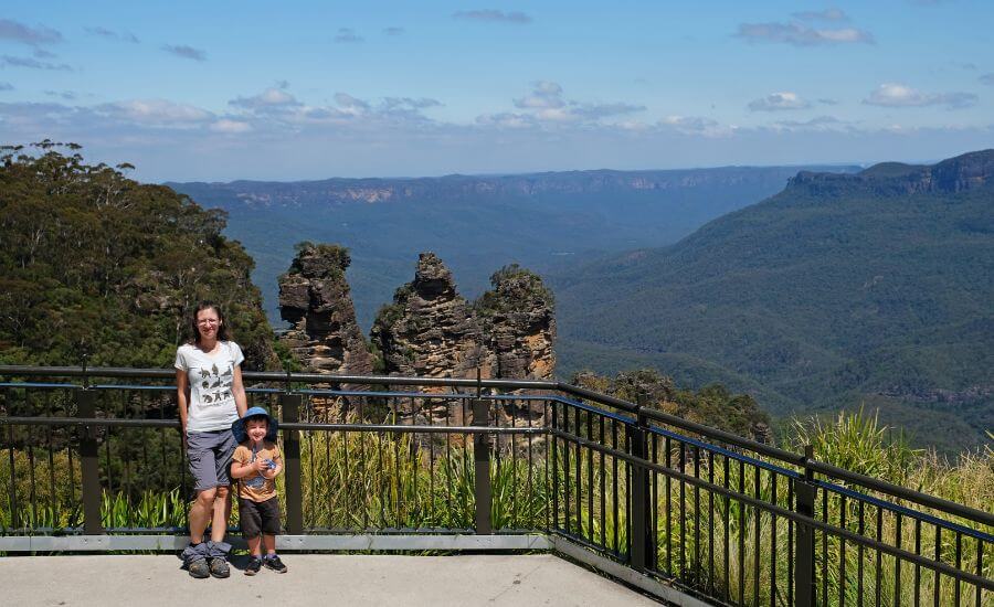
After leaving the Katoomba Cascades, the track takes you to the edge of the canyon and remains there. It’s hard to count all the beautiful lookouts you enjoy along the way, the last one being the Echo Point Lookout that offers a close view of the famous rock formation of the Three Sisters.
The Echo Point Lookout is nicely designed and maintained, with spacious areas and lots of benches to sit down on, but it gets busy, incredibly busy compared to the other lookouts along the walk. The reason is that you can drive directly to this lookout, and I can safely say that everyone who drives through the Blue Mountains or visits on any tour from Sydney stops here. I get it, it’s a wonderful lookout, just expect to share it with lots of other visitors.
Honeymoon Bridge Lookout


You can then continue to the Honeymoon Bridge Lookout. You’ll see the bridge that connects the huge rocks of the Three Sisters to the canyon walls, but the bridge is closed (and will likely remain so). Nevertheless, the Honeymoon Bridge Lookout offers another (and the closest) perspective of the huge rocks towers.
This is also a natural place to turn back, and you’ll pass all the stunning lookouts again as you return to the Katoomba Falls Reserve.
Is it the best Blue Mountains walk for first-timers?
Being easy and located in the most popular area, this hike is what most people choose if they have time for only one walk while visiting the Blue Mountains. As amazing as it is, it’s not my favorite. Not only because of the crowds (which are not at all typical or comparable to this on any of the other trails), but also because walking below giant cliff overhangs and descending into canyons is my favorite thing in the Blue Mountains, and it’s not included in this walk. But to each his own.
If you’re looking for an easy walking track that treats you with an incredible number of scenic lookouts, this is the best choice. If you want to be more adventurous, read on.
Planning to walk the Prince Henry Cliff Walk?
- Trailhead & parking: Katoomba Falls Reserve
- Length: 5.6 – 7 km loop (5.6 km if you don’t hike down to Katoomba Falls)
- Difficulty: easy – medium (without the downhill to Katoomba Falls, the walk is easy)
- See it on a map: 5.6 km walk (without the Underfalls Walk to Katoomba Falls) or the 7 km track that includes Katoomba Falls
- Staying overnight in Katoomba makes it much easier to start early and avoid Echo Point crowds. Check accommodation in Katoomba.
- Visiting from Sydney? Compare car rental prices here.
Wentworth Falls lookouts loop
This 2.6 km loop is short, but the elevation change is about 250 meters, which means you’ll first steeply descend to the bottom of Wentworth Falls, then you’ll have to climb back to the top of the canyon. But with the steepness comes such a dramatic, jaw-dropping scenery which easily makes the effort worth it in my eyes!


The trail that I recommend here is not the same as the Wentworth Falls track you find on the official website of the park. That’s one part of it, but I made it better for you. You’ll follow the Wentworth Falls track, then take the Grand Stairway down to Wentworth Falls, then retrace your steps back on the Undercliff track and the Princes Rock track. This route includes every lookout in the Wentworth Falls area which are worth visiting (Jamison Lookout, Wentworth Falls Lookout, Fletchers Lookout, Rocket Point Lookout, Princes Rock Lookout) and also includes some impressive cliff overhangs (hint: mostly on the Undercliff Track).
187 meters high Wentworth Falls is definitely a highlight, but I was impressed by the route which took us down there just as much. Fletchers Lookout offers the best close view of Wentworth Falls, and soon after that starts the Grand Stairway, which is a route carved into the canyon walls.


As you reach the bottom of Wentworth Falls, you can choose a rock pool you like, or you can walk under one of the smaller cascades at the bottom. It’s the perfect place to just sit down on the smooth rocks, look up to the giant waterfalls and have some snacks before you start climbing up.
Rocket Point Lookout and Princes Rock Lookout will be pretty excuses to stop on your way up. Princes Rock Lookout is one of my favorites in the Blue Mountains, especially in late afternoon sunshine, as Mount Solitary rises out of Jamison Valley.

view from the Princes Rock lookout
Is it the best Blue Mountains walk for first-timers?
Dramatic valley views, cliff faces, several smaller cascades and a majestic, giant waterfall, huge cliff overhangs and lush greenery – this is what the short circuit of the lookouts of the Wentworth Falls area offers. But be prepared for a steep route and wear proper hiking shoes with good grip. While I’d take an elderly relative to the Prince Henry Cliff Walk, I wouldn’t necessarily take them here. Being able to walk a bit is not enough for this track, but if you’re fit for a hike, this is a breathtaking one to choose.

Unfortunately, parts of this route have been closed since 2023. We hope to see it open again, but I understand how hard it could be to repair damages on such a steep route.
Hiking essentials for Wentworth Falls:
- Trailhead & parking: Wentworth Falls car park
- Length: 2.6 km loop
- Difficulty: medium
- See the Wentworth falls lookouts route on a map here.
- Wear proper hiking boots! The Grand Stairway gets slippery after rain. I recommended the Columbia Women’s Newton Ridge Plus boots for womens and the Newton Ridge Plus II for men.
- Staying nearby? Check availability in Wentworth Falls
Grand Canyon track
Blackheat is about 15 minutes drive from Katoomba, and it’s home to several astonishing lookouts and walking tracks. The Grand Canyon track is the most popular – and for a good reason. It’s the most rewarding canyon exploration in the Blue Mountains, with dramatic sandstone walls and waterfalls, creeks and trickling water, abundant greenery and cliff overhangs, and huge ferns that make you feel you’re thrown into the Jurassic Park.

Being a 6 km long loop, it’s not that long, but it descends steeply, and then awaits a hefty hike back up. It’s a technically easy canyon trail though, and most of the time you’re in the shade, so it’s pleasant even on hot summer days. Still, bring plenty of water — we always carry a lightweight 2L hydration pack like this one, because you won’t find drinkable water along the trail.
There’s a large, new car park along Evan Lookout Road – called Grand Canyon car park -, where you can park. The Neates Glen car park and the Evans lookout car park are also along the way, but they’re smaller. Wherever you end up parking, the first portion of the trail is a flat bushwalk along Evans Lookout Road.
Reaching Evans Lookout, there are two lookout platforms that offer unforgettable views of the canyon. Then you start your descent, and believe me, you won’t miss the panoramic views. Because the vibe and the beauties of the canyon are captivating: giant ferns, large tree roots, ever trickling small streams and impressive rock formations surround you, not to mention the canyon walls when you reach the bottom. Depending on recent rains, you’ll notice several narrow, high waterfalls tumbling down in the canyon.


Before you start hiking back up, I recommend a detour to a very scenic and adventurous slot canyon. We’ve only explored the first portion of it, and if you don’t want to swim through deep pools of water, you won’t get too far either. But even this first section was jaw-dropping! The canyon is so narrow, the rock formations are amazing and ferns hang from the vertical walls. If you’re willing to scramble over a few large rocks, you’ll be nicely rewarded. This is the intersection, and the path is quite obvious, though there’s no signage. Once done, return here, and continue up on the stairs.
If you’d like to experience a canyon from the inside — including abseiling and swimming through narrow slots — you can join a guided canyoning tour here (all gear included).


views of the slot canyon
The way up is naturally more tiring than the way down, but it’s not less pretty. You’ll walk under large rock overhangs, look over the creek and the canyon walls, pass several waterfalls – one of which you can walk under.
Is it the best Blue Mountains walk for first-timers?


It’s a very impressive canyon hike, but it requires you to be fit for the steep downhill and uphill. If I were to choose a perfect introduction hike when one of my outdoorsy friends visits, I’d choose the Grand Canyon track. It has astonishing panoramic views of the Blue Mountains (from Evans Lookout) and even more impressive canyon views from up close. And it has all the other typical beautiful features of this park: the temperate rainforest, the huge rock overhangs and lush ferns, the streams and waterfalls.
Grand Canyon Track essentials:
- Trailhead & parking: Grand Canyon car park along Evans Lookout Road (in Blackheath)
- Length: 6 km loop
- Difficulty: medium
- See the Grand Canyon track on a map here.
- Want a more adventurous experience? Join a guided canyoning tour in the Blue Mountains (highly rated & includes gear)
- Wear proper hiking boots. Hiking poles will take the stress of your joints during the steep ascents and descents.
Porters Pass and Centennial Glen Circuit Track
The Porters Pass, Colliers Causeway and Centennial Glen loop is quite similar to the Grand Canyon circuit track in its features, only it’s much less busy. It’s a bit shorter, being a 4.4 km loop, but with about 280 meters elevation gain the steepness is about the same. You climb down to the glen, then up at the end. It’s a beautiful and varied hiking trail, taking you along cliff edges and up to scenic rock plateaus, down to rainforest gullies and huge rock overhangs, to several waterfalls and one particularly unique inside a small slot canyon.

The trail starts at Burton Road in Blackheath, which is a usual residential street with a dead-end. There’s no dedicated trailhead parking, you can park on the street and find the sign for Porters Pass at the end of the road. The trail heads straight into the bush, and you’ll soon reach a signposted junction, where you take the Porters Pass Track. The next junction is not signposted, and the left path is actually a short detour which is worth doing for the views of a nearby cliff wall.
Colliers Causeway


Then you’ll descend into the lush rainforest where trickling water, cooler temperatures, giant overhangs and fern await. It’s like being transported to another world. Leaving the gullies behind, you’ll continue on the Colliers Causeway, alongside an impressive, towering cliff (where temporary waterfalls trickle down after heavy rains).
Centennial Glen
As the path ascends, you’ll find yourself on an uneven staircase hewn into the rock right next to a rushing waterfall. There are handrails for safety. Don’t forget to look up and look down, it’s a fantastic setting!
A narrow section of the canyon follows, and you might need to walk through a stream here after recent rains. And after that watch out for an unsigned junction. Turn left for a detour which is one of the highlights of the trail: an unbelievably pretty slot canyon with a hidden waterfall and plunge pool. As the sun shines down through the narrow canyon it makes it look even more dreamy.

To reach the waterfall you need to walk very briefly along a narrow ledge under the rock overhang, bending down a bit. But the drop to your left is not big, the worst thing is that you’ll get wet (which could be bad enough on a chilly winter day, I admit). In exchange you get one of the most impressive canyon views in the Blue Mountains.
Completing the circuit on the Cliff Top Track
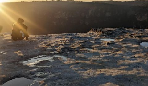
After the detour you continue uphill onto Centennial Glen, then follow the signs for Fort Rock. You’ll walk under a gorgeous waterfall and under impressive cliffs. Fort Rock itself is a huge rock boulder which you can climb for the views of Megalong and Kanimbla Valleys. It’s a beautiful sunset spot.
After Fort Rock the track flattens out, and you can enjoy the scenery until the last stretch of steep uphill at the end. Completing this part during the golden hour makes it truly spectacular.


Overall, it’s not a difficult hiking trail, but you need to be fit and watch your footing. It feels harder than what the distance would suggest, and the steeper sections could be slippery, but there’s no scrambling required.
Porters Pass Track essentials:
- Trailhead & parking: Burton Road in Blackheath (start anti-clockwise)
- Length: 4.4 km loop
- Difficulty: medium
- See the route on a map here.
- Staying in Blackheath? See accommodation options here
- Prefer a guided canyon experience? Check available Blue Mountains canyoning tours
Valley of the Waters Track until Sylvia Falls
The Valley of Waters must be the most charming waterfall hike in the Blue Mountains – except it has been closed ever since we moved to Sydney. But it’s a partial closure, and we could hike to the first two waterfalls: Empress Falls and Sylvia Falls. Even that is enough to make it one of our favorite waterfall trails.
While the Blue Mountains are home to plenty of waterfalls, most of them are more of a trickle than a roaring, thundering waterfall, especially during dry spells. Even those which are several hundred meters high – like Katoomba Falls or Wentworth Falls – are quite narrow. The reason I love Empress Falls and Sylvia Falls is that no matter the time of the year, they have plenty of water, certainly enough to make them look spectacular, and their shape is also very symmetric and pretty.

They’re definitely worth your time, even if you can’t continue further in the Valley of Waters to see the remaining five waterfalls. And even though it’s just a 600 meters walk down to Sylvia Falls, it’s more tiring than you’d expect based on such a short distance. Because it’s steep downhill all the way (and then steep uphill on the way back). The path consists of a seemingly endless number of stairs, then a few metal ladders, with sections of narrow, dirt tracks between the stairs.
Descending from the Conservation Hut to Queen Victoria Lookout

Parking is free at the Conservation Hut, but you rarely find a space. Don’t worry, just park a few minutes walk away along the street.
As you descend on the stairs from the Conservation Hut, the first viewpoint is the Queen Victoria Lookout, offering a lovely sight of the green valley below, surrounded by the dramatic, orange canyon walls on both sides. The other lookout that soon follows looks over Empress Falls, but you can only see the top of the waterfall because of the dense rainforest.
Empress Falls and Sylvia Falls

But from here the trail gets much steeper. You’ll take several metal ladders, and even the stairs are cut into the rocks, and they are more worn off and slippery than before. But they lead you under picturesque rock overhangs, and you’ll pass Isobel Falls – a nice one, but not comparable to what comes after.
When you reach Empress Falls, the trail takes you down to the bottom, which is the best place to enjoy the view of this rushing, pretty, 37 meters high waterfall. The water is much cooler here, you’re definitely down in the rainforest, and you’ll continue down along the stream. Only after a few minutes walk you’ll see Sylvia Falls.


Sylvia Falls is not as high as Empress Falls, but it consists of a handful of pretty cascades, so I was impressed the second time. And it only made me feel more sorry that we couldn’t continue further. The valley views just start to open up and the next waterfall is a few steps away, but the track is closed from here.
Visiting Valley of the Waters?
- Trailhead & parking: Conservation Hut in Wentworth Falls
- Length: 600 meters one-way
- Difficulty: medium
- See the route on a map here.
- A more adventurous way to explore this canyon is joining this guided abseiling and canyoning tour.
- Book accommodation near Wentworth Falls.
- Bring waterproof hiking shoes — these are the ones we use: for womens and for men.
Walls Lookout along the Bells Line of Road
The Walls Lookout is one of the best lookouts in the Blue Mountains. A bold statement, I know, especially that you need to make an effort to reach it. It’s not located in the most popular Katoomba – Leura – Blackheath area, rather along the lesser-known Bells Line of Road, and it also requires a 1.3 km of walking to reach the lookout. But it offers enough to make your visit worth it.

First of all, driving the Bells Line of Road is much more scenic than driving through Katoomba and Blackheath. And Walls Lookout itself is at the edge of a scenic ridge, looking over the Grose Valley and offering close views of the surrounding canyon walls. Views that you’ll likely have for yourself, as it’s one of the least busy lookouts in the Blue Mountains, probably because it’s so out of the way.
It starts from a dirt parking lot right at the beginning of Pierces Pass Road. This road is not paved – though any car could manage it with some caution, you don’t need to. The parking area for the Walls Lookout track is immediately after you turn onto Pierces Pass Road.

It’s a steadily ascending trail that runs on a scenic ridge, with a steeper section just before the end. It’s quite suitable for all skill levels and also for families, but you should wear proper shoes. It’s not a walk, but a real hike, with uneven terrain.
Walls Lookout is not a purpose-built lookout platform, but a large area on top of a cliff which naturally offers breathtaking views. This also means that there’s no safety fence, so keep your eyes on small children and keep them close. The area is large enough so that you can stay well away from the edge.
Overall, this is a short hike, but it’s very scenic, is off the main tourist track in the Blue Mountains and is delightful to do with kids.
Walls Lookout walk essentials:
- Trailhead & parking: Walls Lookout track parking (at the beginning of Pierces Pass Road)
- Length: 1.3 km one-way
- Difficulty: easy
- See the Walls Lookout track on a map here.
Driving the Bells Line of Road?
- Compare car rental prices from Sydney Airport.
- Looking for accommodation along Bells Line of Road? See options in Bilpin & Lithgow.
- Consider renting a campervan if you’re road‑tripping Australia
Are these Blue Mountains walks family-friendly?
We completed all of these trails with 3-year-old and 4-year-old Tomi. That’s no rule for another child or for another family, of course, and I admit we are passionate hikers and are out on the trails every weekend. If you want to carry your baby or toddler, or you want to walk with your child, you can safely do so on these tracks. Some sections are steep, and there are steep drop offs (we’re talking about canyon walls here, after all), but the fencing is quite good, and you have the option to hold your kid’s hand when you find it necessary (the tracks are wide enough to do so).

Some of the walks have significant elevation changes, and you should calculate with that. Would you be able to carry your toddler up? Would your kid be willing to climb the way up? If you haven’t done a 6 km hike before, don’t choose the 6 km loop in the Grand Canyon as a first one, because the elevation change makes it more exhausting than a general 6 km route. But you’ll have plenty of chances to stop and rest along every walking track.
Looking for more family-friendly walks near Sydney?
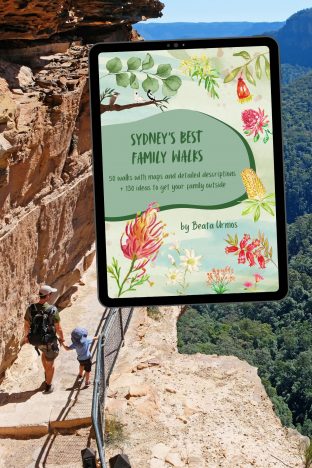
If you loved exploring the Blue Mountains with kids, you’ll love my ebook Sydney’s Best Family Walks.
It includes:
• 50 kid-tested trails
• Parking + difficulty details
• Pram access info
• Unique “Play Factor” notes
• 130+ bonus nature play ideas & printables
Make your next family adventure simple and stress-free.
If you’ve ever hiked with your kids in the Alps or in the Rocky Mountains, well, this will be much easier. The easiest is the Prince Henry Cliff Walk because of the minimal elevation change, followed by the short and relatively easy hike up to the Walls Lookout. If you’d like to try a short, steep route, do the Wentworth Falls lookouts loop or the Valley of the Waters track until Empress Falls.
Proper shoes are just as important for kids as they’re for you. Northside kids’ boots have good grip and protect the ankles.
Best time to hike in the Blue Mountains

Well, here’s a place where it’s truly delightful to go hiking any time of the year. I mean it. We enjoy the cool canyons, gullies and swimming holes in the summer, the sunny cliff top walks in the winter, the autumn colors in Katoomba, Leura and Blackheath (a rare thing when you live in Sydney), and the vibrant red waratahs in spring. The Blue Mountains Botanic Garden in Mount Tomah is also spectacular in spring, with carpets of daffodils, blooming rhododendrons, azaleas and camellias, and the cherry blossoms of Leura Mall are the favorite Instagram spot for local couples. And we enjoy the sound of water and the lush greenery of the temperate rainforests year-round.
Every season offers something spectacular in the Blue Mountains, and every season is pleasant for outdoor activities. The Blue Mountains are evergreen, and while winter is cooler (around 5 degrees Celsius), snow is rare.
Camping in the Blue Mountains
If you’re spending more than a day in the Blue Mountains, I highly recommend staying overnight.
Yes, I’m an avid camper — but I genuinely believe camping is the best way to experience this region. You’ll start your hikes earlier (before the tour buses arrive), see more wildlife at dusk and dawn, and feel the atmosphere of the eucalyptus forest in a completely different way.
There are options for every style of traveller:
- Simple national park campgrounds surrounded by bushland
- Family‑friendly holiday parks with cabins and powered sites
- Remote riverside camping for adventurous explorers

For example:
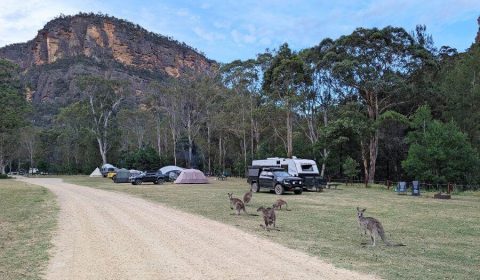
Glenbrook area (closest to Sydney)
Euroka and Murphys Glen are affordable NSW National Parks campgrounds with basic facilities (toilets, picnic tables, BBQs — but no drinking water). They’re great for tent camping and often have kangaroos grazing nearby.
Ingenia Holidays Nepean River offers a more comfortable setup with cabins, powered sites, a pool and playground.
Katoomba area (best for hiking access)
Katoomba Tourist Park is a great base for walks like the Prince Henry Cliff Walk and Wentworth Falls, with powered sites and cabins.
Bells Line of Road (more remote)
Burralow Creek campground feels far wilder and requires 4WD access — perfect if you want fewer crowds and don’t mind basic facilities.
That’s just the short version. For a full breakdown of campgrounds (including Blackheath, Wollemi and Kanangra‑Boyd), seasonal advice, costs, family tips, and remote camping safety, read my complete Blue Mountains camping guide here.
If hiking is your priority, camping near your chosen trailhead makes early starts much easier.
My favorite camping gear for the Blue Mountains
A reliable, quick‑setup gear makes all the difference. Here’s what has worked best for us after many weekends camping in the mountains:
- Dome tent with vestibule – tough enough for coastal wind and mountain drizzle, with room for boots and packs outside
- Self‑inflating sleeping mat – essential for comfort and warmth when the ground gets cold overnight
- Lightweight camp stove – to have your coffee, ham and eggs even on camp days
- Rechargeable LED lantern – bright enough for camp kitchen duty yet gentle enough for inside the tent at bedtime
- Compact cookware set – this basic set comes with a stove
- Foldable camp chair – who needs a reason for them? 🙂
Not camping? Here’s where to stay in the Blue Mountains
Katoomba is in the heart of the Blue Mountains, the main town and the center of tourism. It’s a great base to stay on a first visit and allows easy access for most of the walks in this post. (Just to be clear, easy access means to have a car and drive a short distance.)
Your best budget accommodation option in Katoomba is the YHA Blue Mountains Katoomba. It has both dorm rooms and private rooms, a garden, free private parking, a shared lounge and a terrace (and barbecue, because it’s Australia). The spaces are simple, but nice and clean, and the hostel has a great atmosphere overall.

beautiful greenery on the Grand Canyon track
The Metropole Guest House in Katoomba is a great mid-range option. This 1930’s style guesthouse combines modern comfort with old world charm, and it’s right behind the train station. There’s a restaurant, a library and an elegant lounge with a game area on-site.
If you’re looking for luxurious accommodation in a heritage-listed manor house, Carrington Hotel with its stained glass Art Nouveau features, elegant rooms and fine dining options is the best choice. It’s only 200 meters from the train station, which makes it easily reachable from Sydney by train.
Accommodation along the Bells Line of Road is scarcer to come by. The largest towns are Bilpin and Lithgow. Zig Zag Motel & Apartments could be a good choice for a budget-friendly stay. Tomah Retreat offers a remote, relaxing hideaway in Mount Tomah, and you have the option to sign up for an on-site meditation retreat.
What we bring on every Blue Mountains hike

Packing right makes the difference between a casual stroll and a comfortable adventure. This is our basic hiking gear that we never leave home without:
- Waterproof trail shoes with solid grip – sandstone paths get slick fast after rain, and a good tread keeps everyone upright. You need real hiking boots here, like the Newton Ridge Plus – for women and for men.
- Collapsible trekking poles – they pack small, yet save your knees on steep canyon stairways.
- Two‑litre hydration pack – hands‑free drinking is a blessing on steep and narrow tracks.
- Compact rain poncho – because when it rains, it pours!
- Foldable sit mat – weighs almost nothing, insulation for cold rock benches and damp ground during snack breaks
- UV‑blocking hat – protects from sun on exposed cliff tops
- Mini first‑aid pouch – barely noticeable in weight but priceless when someone meets a leech or branch scratch.
Leave a Reply